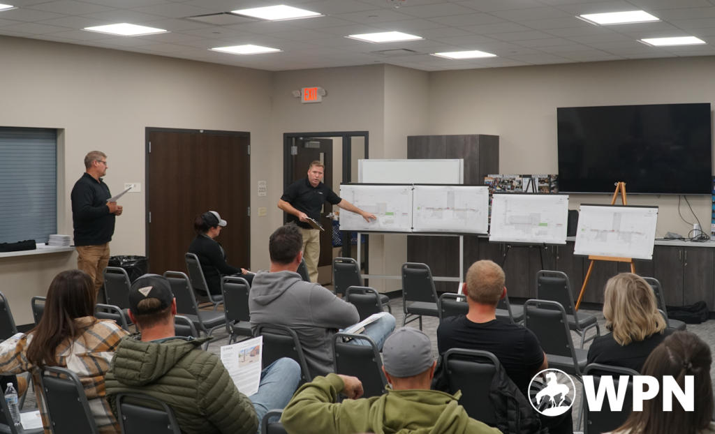
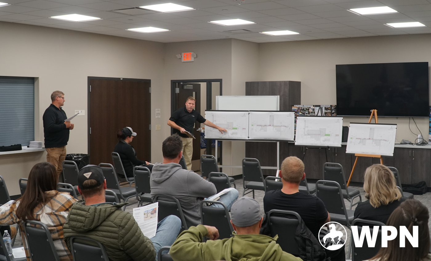

WAUPUN — Plans for the Main St Back Alley Improvement Project were presented to Waupun business owners at a public informational meeting earlier this month.
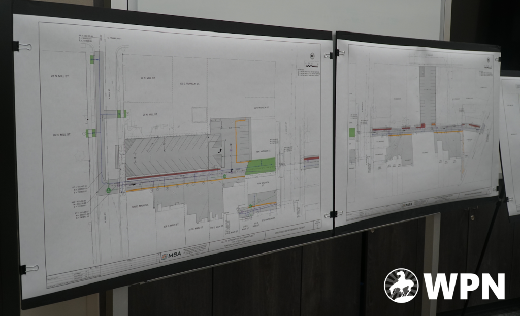
The Back Alley Improvement Project is an effort to add parking and increase efficiency to the north side of the 300 and 400 blocks of Main St. The 300 block is between N Mill St and N Madison, and the 400 block is between N Madison and Fond du Lac St.
The meeting was held Wednesday, November 5, 2025 at the Waupun Community Center, 520 McKinely St. Business owners and property owners of these blocks were all directly invited to the meeting.
Public Works Director Jeff Daane began the meeting by introducing MSA project manager Jason Laue, who is the one working with the City on the project.
MSA has worked with the City of Waupun on municipal projects for several years, previously consulted on the Shaler Dr extension project, stormwater ponds, street grading, and previous plans for the parking lot on the south 300 block of Main St—behind the old Senior Center and Masonic Lodge.
Two versions of the plans were presented with different scenarios. The first scenario only included land owned by the City of Waupun or managed by the city in the right-of-way. The second included the privately owned land behind the businesses if the property owners were to buy into the project.
The project would include completely repaved parking lots, new concrete medians between parking and the alley, sanitary sewer and water main improvements. It would turn the N Mill St to N Madison St alley into one-way drives to increase the number of parking spaces and reduce confusion for driving in the alleys, now possible after the City purchased and demolished the small white building previously in the middle of the parking lot. A green space would also be placed between The Clothing Pallet and VandeCastle Chiropractic.
After Laue outlined the project, business owners were provided a time to ask questions.
One question was asked about whether the concrete median dividers for the alleys could be grass or gravel, or could include potted plants such as trees or bushes. Laue said that this had been considered, but that they recommended colored concrete for the low maintenance requirements. Grass would have difficulty growing in such a small space and require mowing, and gravel would spill into the driving and parking areas. He said they also were considering having potted trees on the median, which are two and a half feet wide.
Another question was brought up about the grass in the 18-20ft area between The Clothing Pallet and VandeCastle Chiropractic, whether grass will actually be able to grow there. Laue said they were planning a sidewalk on the south side along VandeCastle, which should provide a walking path and a buffer between the grass and the building so as to not prohibit growth. They were also planning on putting down sod instead of grass seed, as to prevent it from being muddy.
One of the original intentions for the project was to bury the utility poles behind the businesses, but this was found to be prohibitively expensive and in some spots the existing infrastructure made it impossible. Waupun Utilities Director Steve Brooks also explained that there’s also a lot of critical telecom infrastructure on the cables, and putting it underground was far beyond the scope of the project—but that they were planning to work with the telecom companies to clean up the utility poles to better utilize space.
A question was asked about whether N Mill St will become one-way as well, which Schlieve said it won’t at this time—only the alley between N Mill St and N Madison St.
Tom Kulczewski, owner of Real Sportscards-Wisconsin at 324 E Main St, asked whether the parking lot at the corner of E Franklin St and N Madison St would become one-way parking too. Daane said they had kicked the idea around, but decided to leave that area alone and only change the parts outlined in the plans—which only includes the area behind The Clothing Pallet.
Kulczewski said it might be confusing to explain to non-residents how to find parking behind the buildings. He said that he has had difficulty in the past explaining to customers how to find parking, and that the one-way access and green space might make it even harder for customers to find. Laue said they were planning to put up signage indicating where to find the parking, and one-way signs.
Three new parking spaces on N Madison street will likely open up where the east alley access is being replaced with green space.
After all questions were addressed, Laue turned the meeting over to Daane, who explained the next steps of the process. Envelopes were handed to each property or business owner with the opportunities specific to their property.
“The City is going to do 100% of the cost for the alley project proper,” Daane said. “With that, there is a really good opportunity for the private property owners to utilitize the city having hired a contractor to come in to potentially get your own water and sewer redone, and to get the blacktop area redone behind your buildings. This is a potentially cost-savings opportunity for you since you will be able to piggy-back off the city’s contractor already in there.”
“As part of that, the City is willing to offer an incentive package for you to do that,” he said. “And part of that is the City is going to pay for 50% of the cost for the work done on the private property there. The City is willing to front the cost for the project and pay for it all. As you work your way down there you will see some repayment terms and options.”
Daane explained some of the options, before saying, “We’re trying to get it so it’s as cost affordable for you as we can get it as cleaned up as possible for this project.”
A question was asked about whether the private parking lots will get repaved, which Schlieve said that they could have a conversation about doing that too.
“Just to be clear how we are financing this project: it’s not a project that goes on the levy, it is a project that gets paid for by Tax Increment District #3, which has funded all of the CDA activities for decades,” Schlieve said. “That TID comes to the end of its expenditure period in 2027, which is about 18 months away from that. The incentive is a short-lived incentive, because the funds dry up in 2027 so there will never be a cheaper time to do this.”
Schlieve went on to explain some of the financials behind the project, and how the TID works.
“From a timing perspective, tonight you’ll be able to eyeball this and give some feedback,” she said. “Our goal is to have designs finalized by January—and we will have to bid this project—with construction starting in the spring, completing in the fall. We talked about trying to get a completion date of September so that we could get ahead of a lot of events that could be impacted by this.”
Both blocks (between N Mill and N Madison, and between N Madison and Fond du Lac) will be started at the same time.
“What we’re trying to understand right now is your level of interest in participating so we can finalize designs,” Schlieve said. “It gives us cost estimates, as we’ll have to tailor project scope to your needs which we can figure out one-on-one, but our goal here is to get this confirmed by the early part of December. We’re looking for you to dialogue with us, so we can get that figured out.”
“It’s because of the investments you’ve made that this is even possible,” she said. “That’s how a TID performs, it’s capturing new value that’s been generated because of your investments since the creation of this TID back in the early 2000s.”
A final question was asked about whether the City will piecemeal work around properties if the property owners decline to have work done on their property. Schlieve said they would prefer not to, but they would work around it if they need to.
Questions about the project can be brought to City Hall.